Canadian Safe Boating Course
Chapter 7: The Buoyage System
In 1983, Canada adopted the buoyage system,
or aids to navigation, used internationally.
This system includes port hand buoys, starboard
hand buoys, cardinal buoys and special buoys.
Aids to Navigation
Aids to navigation are devices (buoys) or
systems (collision regulations), that are
external to the pleasure craft. They are
provided to help the operator of a pleasure
craft determine position and course. They can
additionally warn the operator of dangers or
obstructions and advise the operator of the
location of the best or preferred route.
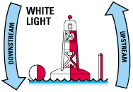
Port Hand and Starboard Hand Buoys
Port hand buoys are green and starboard hand
buoys are red. They show which side of a channel
is safest to travel; accordingly, they mark
channels or hazards. Generally, green buoys
must be passed on the left side of a craft
heading upstream, i.e., against the current.
Red buoys must be kept on the right side of a
craft when proceeding in the upstream direction.
A simple rule is red to the right when
returning, or the three “R’s”: red, right,
return.
In many places, the direction of the current
is determined by consensus or by the tide. It
is important to be thoroughly familiar with the
aids to navigation in your region.
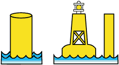
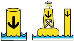
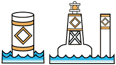
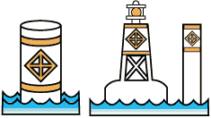
Port Hand Buoys
Green in colour. They
can be shaped as:
If they do not have a
green light they will be flat on top |
 |
Starboard Hand Buoys
Red in colour. They
can be shaped as:
If they do not have a
red light they will be conical on top. |
Green port hand buoys
- marks the port (left) side of a channel
or the location of a danger and must be kept
on the port (left) side of a pleasure craft
when proceeding in the upstream direction;
- it is coloured green;
- displays identification letter(s) and
odd number(s);
- if it carries a top mark, the top mark
is a single green cylinder;
- if it carries a light, the light is
green and is a flashing (FI) 4 s or quick
flashing (Q) 1 s;
- if the buoy does not carry a light, it
has a flat top.
Red starboard hand buoys
- Marks the starboard (right) side of a
channel or the location of a danger and must
be kept on the starboard (right) side of a
pleasure craft when proceeding in the
upstream direction;
- is coloured red;
- displays identification letter(s) and
even number(s);
- if it carries a top mark, the top mark
is a single red cone, pointing upward;
- if it carries a light, the light is red
and is a flashing (F1) 4 s or quick flashing
(Q) 1 s;
- if the buoy does not carry a light, it
has a pointed top.
Bifurcation buoys
- You may pass buoys with red and green
bands on either side in the upstream
direction.
- The main or preferred channel is shown
by the colour of the top band.
- For example, if a red band is on top,
you should keep the buoys on your starboard
(right) side.
 Know
that a port hand day beacon is a beacon that
Know
that a port hand day beacon is a beacon that
- marks the port (left) side of a channel
or the location of a danger during daylight
hours
- it must be kept on the port (left) side
of a pleasure craft when proceeding
upstream;
- it is square with a black or green
coloured square centered on a white
background with a green reflecting border ..
it may display an odd number made of white
reflecting material
 Know
that a starboard hand day beacon is a beacon
that
Know
that a starboard hand day beacon is a beacon
that
- marks the starboard (right) side of a
channel or the location of a danger during
daylight hours and must be kept on the
starboard (right) side of a pleasure craft
when proceeding upstream;
- it is a red coloured triangle centered
on a white background with a red reflecting
border; and may display an even number made
of white reflecting material
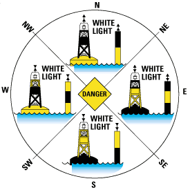
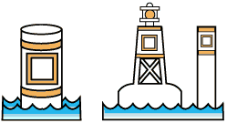
Cardinal Buoys
There are four types of cardinal buoys:
north, south, west and east. Cardinal buoys are
used to indicate the direction of the safest
waters. A north cardinal buoy indicates that
the deepest or safest water exists to the north
of the buoy. The vessel must travel north past
the north buoy; in this way, the buoy is between
the hazard and the craft. The same principles
apply to all of the cardinal buoys. For more
details on the hazard indicated by the buoy, a
nautical chart must be consulted; the buoyage
system is therefore used in tandem with nautical
charts.
There are two ways to distinguish among
cardinal buoys: by colour and by the shape of
their conical top marks. The direction of the
point indicates the type of cardinal buoy.
Accordingly, the cones on a north cardinal buoy
point north, and on a south cardinal buoy, point
south.
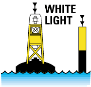
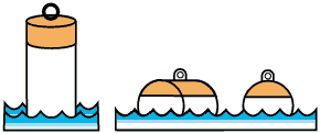
North Cardinal Buoy
 |
- A north cardinal buoy is located
so that the safest water exists to
the north of it
- It is coloured black and yellow
- The top half is painted black
indicating that it is a north buoy
.. the lower half is painted yellow
- If this buoy does not carry a
light, it will be spar shaped
- If it carries a top mark .. they
will both point upwards to indicate
north
|
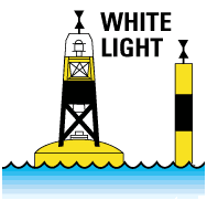
 South
Cardinal Buoy
South
Cardinal Buoy
- A south cardinal buoy indicates that the
safest water exists to the south of it.
- It is coloured black and yellow
- The black is positioned on the bottom
indicating that it is pointing south .. the
upper portion is painted yellow
- If this buoy does not carry a light, it
will be spar shaped
- If it carries a top mark .. they will
both point downward to indicate south
East Cardinal Buoy
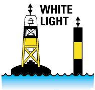 |
- An east cardinal buoy is located
to indicate that the safest water
exists to the east of it
- It is coloured black and yellow
- the black is positioned on the
top and the bottom with the yellow
portion in the middle to indicate
that it is an east buoy
- If this buoy does not carry a
light, it shall be spar shaped
- If it carries a top mark .. they
will point in opposite directions to
indicate that it is an east buoy
|
 West
Cardinal Buoy
West
Cardinal Buoy
- A west cardinal buoy is located to
indicate that the safest water exists to the
west of it.
- It is coloured black and yellow
- The black is positioned in the center to
indicate that it is a west buoy .. the
yellow is positioned top and bottom.
- If this buoy does not carry a light, it
shape be spar shaped
- If it carries a top mark .. they will
point in towards each other to indicate that
it is a west buoy
As with any buoy ... when encountered you
should refer to your Nautical Charts for
specific information.
Light Characteristics of Cardinal Buoys
The lights on all cardinal buoys will be
white in colour, (if the buoy is so equipped).
In order to identify these buoys in darkness or
reduced visibility, each one can be
distinguished by different light flash
characteristics.
The flash characteristics are based on the
same numbering principle as an ordinary time
clock.
The number of flashes coincides with the
position of the face of the clock.
| |
North buoys flash at the
rate of 1 per second or 60 per minute. A
very quick flash can also be used — 10
flashes every 5 seconds. |
|
|
West buoys flash at the
rate of 9 times in 15 seconds. A very
quick flash can also be used — 9 flashes
every 10 seconds. |
 |
East buoys flash at the
rate of 3 times every 10 seconds. A very
quick flash can also be used — 3 flashes
every 5 seconds |
| |
South buoys flash at the
rate of 6 times in 15 seconds followed
by a single long flash. A very quick
flash can also be used — 6 flashes every
10 seconds plus 1 longer flash at the
end of each group to mark the end of 1
flash cycle. |
|
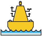
Special Buoys
Finally, special buoys serve a variety of
purposes. They are not primarily aids to
navigation, but rather provide the boat operator
with a host of information. Some are cautionary
buoys to mark firing range or seaplane bases,
while others gather weather information, locate
prohibited areas or mark designated mooring
areas. The shape of the special buoys is not
significant; they are identified by their
symbols, drawings and colours.
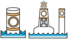
Cautionary Buoy
 |
- they mark an area where mariners
are to be warned of dangers such as
firing ranges, racing courses,
seaplane bases, underwater
structures or areas where no safe
through channel exists and of
traffic separations.
- they are coloured yellow
- they display identification
letters
- if it carries a top mark it
shall be a single yellow ‘X’ shape
- if it carries a light, the light
shall be yellow and flash once every
4 seconds
|
 Anchorage
Buoy
Anchorage
Buoy
- it is used to indicate areas which are
favourable
- for overnight anchoring • they are
yellow in colour
- they usually have an anchor symbol
clearly visible
- if it carries a light the light is
yellow and it will flash once every 4
seconds.
Mooring Buoy
 |
- used to moor or secure vessels
- it is the ONLY buoy that you may
legally tie your vessel to
- usually found in designated
anchorage areas
- when in reduced visibility, be
aware that other vessels may be
present and tied up
|
 Control
Buoy
Control
Buoy
- it is used to mark an area where boating
is restricted
- it is coloured white
- it has an orange, open-faced circle on
two opposite sides and two orange horizontal
bands, one above and one below the circle
- a black figure or symbol inside the
orange circle indicates the nature of the
restriction.
- if it carries a light is shall be yellow
and flash once every 4 seconds
Hazard Buoy
 |
- it is a buoy which marks random
hazards such as rocks and shoals
- it is white in colour
- it has an orange diamond on two
opposite sides and two orange
horizontal bands, one above and one
below the diamond symbols
- if it carries a light the light
is yellow and flashes once every 4
seconds
|
 Information
Buoy
Information
Buoy
- it displays information of interest to
boaters. The message can either be
displayed using lettering or symbols.
- it is white in colour
- it can be distinguished by the orange
open-faced square symbol on opposite sides
and the two horizontal bands, one above and
one below the square.
- if it carries a light it shall be yellow
and it will flash once every 4 seconds
Swimming Buoy
 |
- it is used to mark the perimeter
of a swimming area
- it is white in colour
- if it carries a light, the light
is yellow and it will flash once
every 4 seconds.
|
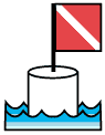 Diving
Buoy
Diving
Buoy
- it is used to mark an area where scuba
or other such diving activity is in progress
- it is coloured white and it carries a
red flag not less than 50 centimetres square
with a white diagonal stripe extending from
the tip of the hoist to the bottom of the
fly
- if it carries a light the light shall be
yellow and flash once every 4 seconds
 Particular
care must be taken when boating in waters where
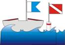
there are divers. A vessel engaged in diving
must display a blue and white flag
(International Code A Flag, see left). A red and
white flag carried on a buoy is used to mark
areas where diving is in progress, although
divers may stray from the boundaries of the
marked areas.
Particular
care must be taken when boating in waters where
there are divers. A vessel engaged in diving
must display a blue and white flag
(International Code A Flag, see left). A red and
white flag carried on a buoy is used to mark
areas where diving is in progress, although
divers may stray from the boundaries of the
marked areas.
Be sure you know what the ‘diver down’ flags
look like. If you see either flag, keep well
clear of the vessel and diving site, and move at
slow speed.
Keep Out Buoy
 |
- A keep out buoy marks an area in
which boats are prohibited
- it is white in colour
- it has an orange diamond
containing an orange cross on two
opposite sides and two orange
horizontal bands .. one above and
one below the diamond symbols
- if it carries a light the light
is yellow .. flashing once every 4
seconds.
|
 Scientific
Buoys (O.D.A.S.)
Scientific
Buoys (O.D.A.S.)
- An ocean data acquisition system buoy
collects meteorological and other
scientific data
Fairway Buoy
 |
- usually found at the entrances
to channels or used to mark the
center of a channel
- it may be passed on either side
but should be kept on the port
(left) side of your vessel when
proceeding in either direction
|
 Isolated
Danger Buoy
Isolated
Danger Buoy
- it is used to mark an isolated hazard in
waters which are otherwise navigable.
- it is usually moored directly on or
above the danger
- it is used to mark a large rock, shoal
or sunken ship
In addition to the above mentioned special
buoys, you could also encounter posted command
signs or warning signs. These can be used to
relay a host of information or provide warnings
of impending danger. Some of these are:
- no wake zones
- no anchorage area signs
- speed limit zone signs
- low head dam hazard signs
- overhead or underwater power line hazard
signs
- pipe line hazards signs
It cannot be stressed enough that every time
you encounter a sign or buoy you should
reference your nautical charts to ensure that
you correctly interpret the information.
The Nautical Chart
The Different Types of Chart
A simple visit to a map store will quickly
convince you of the vast range of products
available. Outdoor enthusiasts can find
topographical maps for mountain excursions, or
guide maps to lakes and rivers to plan their
canoe expeditions.
Naturally, travelers can plan their trips
with a land, tourist or road map, and farmers
can see the boundaries of their fields on a farm
map. For boaters, the nautical chart is vital
tool.
Main Features of a Nautical Chart
Nautical charts provide information on
waterways. They give useful information to
boaters, especially on water depth, the type of
bottom, the type of shoreline, current
direction, coastal altitude, easily identifiable
landmarks and aids to navigation.
The Canadian Hydrographic Service publishes
all nautical charts. For pleasure craft, large
scale maps (i.e., covering a small portion of
the region) are often the most useful because of
all the detail they contain.
To know which regional chart is most
appropriate for your activity, consult the
Nautical Chart Catalogue. This catalogue is a
large map showing the area covered by each
available chart. For information on how to
obtain charts, contact the Canadian Hydrographic
Service.
Importance of the Nautical Chart to Boaters
Charts provide a host of information to
boaters that only detailed knowledge and
experience of the waterway could replace.
Using a nautical chart makes the boaters task
in a rescue situation easier in many ways. It:
- identifies a launch site
- shows the best route in light of
currents, rapids, obstacles, etc.
- shows the location of waterway
- allows for an assessment of distances
- shows location on the water.
On receiving a distress call, the time may
not seem right to carefully study a nautical
chart. However, if the chart is available, the
knowledge gained could mean the difference
between locating and successfully helping out at
a water accident or a tragedy.
Topographical maps are maps of the land areas
depicting natural and artificial features of the
land, including elevation contours, shoreline,
rocks, land features above water, and cultural
features:
- They are intended primarily for the use
of the general public on the land;
- They are published by Natural Resources
Canada and some provincial authorities;
- 3 They are sometimes used when
navigational maps (charts) are not
available, but they usually do not depict:
underwater hazards, marine aids to
navigation, channels, anchorage areas etc.
Other Navigation Aids
A magnetic compass can be used to help the
operator of a pleasure craft find directions.
It must be remembered however that a magnetic
compass is influenced by the proximity of
metallic and/or electrical devices. In order to
avoid false information, make certain that the
compass is mounted in an area free of magnetic
and electrical interference.